NMSS-17 and NMSS-18
NMSS-16, NMSS-17, NMSS-18 were all scheduled to be launched during the 2015 Duke City Hamfest on August 8, 2015. NMSS-16 was to be launched well south of the hamfest venue while 17 and 18 were to be launched at the venue.
NMSS-16 was scrubbed due to low visibility and was rescheduled for August 29, 2015. A separate archive page has been created for it.
NMSS-17 and 18 were launched on schedule but technical issues resulted in complete loss of communication with NMSS-18. To date it has not been recovered. NMSS-17 landed in a remote location on Santa Ana Pueblo property so recovery was delayed a couple of days. The following timeline describes the launch in more detail.
Update: 8/15/2015 at 4:26 PM MDT
NMSS-17 (VHS balloon) was recovered on Monday August 10 thanks to the help of Glen Harper and the Santa Ana Pueblo. The landing spot was approx 35d 25.23’N x 106d 32.2′ W. The equipment was in good shape and data has been downloaded form the experiments.
NMSS-18 (WMHS balloon) is still MIA. Scott Stevenson, KC5VVB a private pilot, has made two flights over what we believe is close to the landing site but no joy to date.
One correction: The original ascent rate calculation was in error: The actual ascent rate was:
- Start time:9:48:55 @ 5229 feet:
- Max altitude was at 10:46:51 @ 98,846 feet
which gives an ascent rate of 93617/3476 = 26.93 feet/sec = 8.2M/s. The wrong start time was used for the original calculation.
Update: 8/9/2015 at 4:15 PM MDT
The Spot Tracker on NMSS-18 (VHS balloon) appears to have come alive again. Perhaps the wind caused the payload to turn slightly allowing it to communicate with the satellite. The coordinates provided are
35.42067N, -106.53749W time: 7:50:48 AM MDT which is on Santa Ana Pueblo property.
APRS packets were also received again starting at about 5:30PM MDT on Saturday 8/8/2015. The reported altitude is about 5,770 feet which is much lower than reported below. The last APRS report to date was at 1:54 PM MDT on 8/9/2015. The APRS location reported at that time was 35.4205N, -106.5375W.
The recovery team worked for about 7 hours on Saturday with pueblo staff and law enforcement. They reported that all were kind, very professional and did all they could to help. However the balloon is in a area deemed sacred and were eventually denied access. The recovery team did get the names of other pueblo officials that may be able to arrange access. In any case, recovery will take the best part of a day and require a very high profile 4×4, ATV, or horses because of the ruggedness of the terrain.
Here is a Google Earth view of the landing site. Click on the image for a full size version.
Max altitude was reached 7,555 seconds into the mission. Start altitude was 1,559 meters. Max altitude was approx 30,128 meters. This gives an average ascent rate of 28,569/7,555 = ~3.78m/s
Update: See above for correction. Ascent rate was approx 8.2M/s
Descent rate was approx 20m/s
UPDATE: 8/9/2015 at 8:30AM MDT
Scott Stevenson, KC5VVB, says there appears to be a 4WD path to the balloon site (as seen on Google Earth). Scott is a private pilot and plans to fly over the area this morning to see if he can spot the balloon as well as locate NMSS-17. Both balloons were of the same type, had similar payload weight and gas fill so we hope they landed near each other.
Kevin Nichols, KA7OFR, says his Google Earth overlay indicates the balloon is on the Santa Ana Pueblo (assuming our landing coordinate is accurate).
UPDATE: 8/8/2015 at 4PM MDT
NMSS-16 was scrubbed due to poor visibility. FAA rules require 50% clear skies for a launch. The NMSS-16 site was approximately 70-90% cloud cover (varied as the day went on, generally getting worse with time). The launch will be rescheduled for a weekend later in August.
Information on NMSS-17 and NMSS-18 as of 4:00 PM MDT is speculation based on observing APRS traffic. Better information will be posted as it becomes available.
NMSS-17 appeared to have equipment failure and no APRS packets were received during the flight. We may have SPOT data on it’s location. Stand by for that info
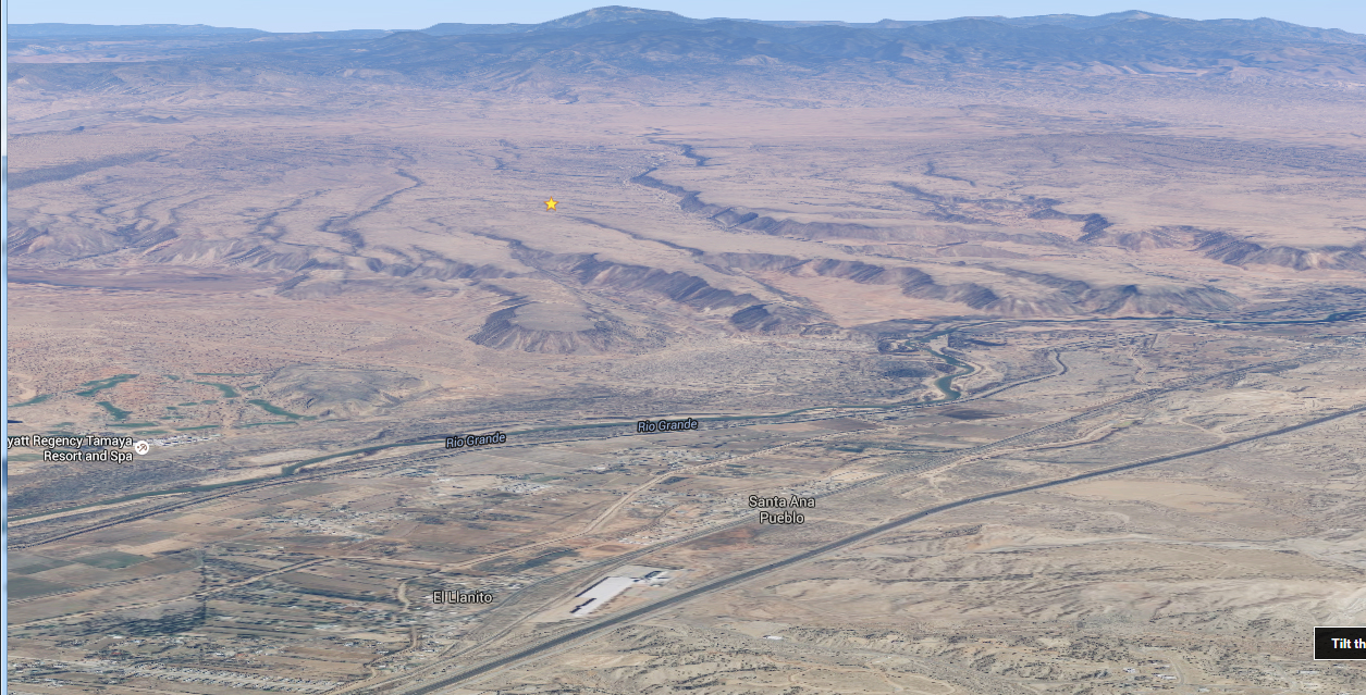
NMSS-18 reached an altitude of approx 98,846 feet (that was the last APRS packet before the burst). Unfortunately it appears to have landed in a spot that will be very difficult to recover. See image below. The recovery team appears to have visited the area that will get them as close as possible by vehicle. The hike appears to be difficult: 1/3 mile vertical climb and a linear hike of about 1.3 miles. The landing site appears to be on Santa Ana (or possibly San Felipe) Pueblo land.
The recovery team appears to have returned home — presumably because there was not enough daylight to accomplish a recovery.
More accurate info will be provided as we get it.
Click on an image for a better view.
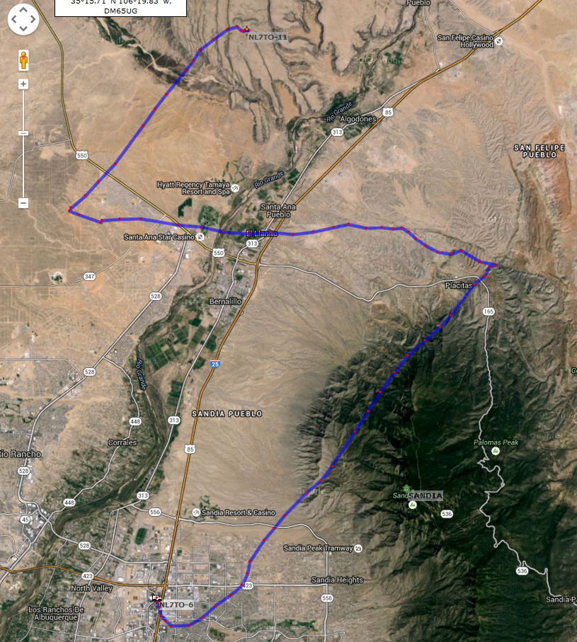
NMSS-18 Flight Path
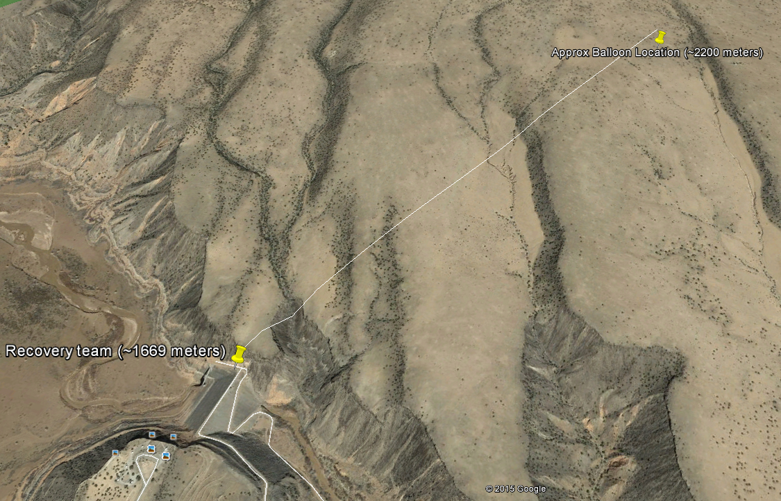
NMSS-18 Landing Site
Flight Number: NMSS-16, NMSS-17, and NMSS-18
Scheduled launch date: August 8, 2015
Scheduled payload: Various (see below)
Flight Objectives: Hamfest Demonstration, STEM
Track the flights here: http://nm-ss.org/launch-information/next-launch/track/
This flight will feature a three balloon launch to support the Duke City Hamfest in Albuquerque, New Mexico. NMSS-16 will be launched from a remote location south of the hamfest venue while NMSS-17 and NMSS-18 will be launched from the hamfest.
NMSS-16 will not only support the hamfest but will be an experimental flight to test equipment. One of the payloads will be a cross band repeater. Repeater uplink (the frequency you talk on) will be UHF, 449.18 (no tone, no offset). The down link (the frequency you listen to will be on 147.76
Here are a list of APRS beacons that will be used for the flight. All will beacon in 144.39. VHS = Valley High School. WMHS = West Mesa High School.
1 – VHS Cluster NMSS-18 AIO APRS NM5SS-9 rate ??
2 – VHS Cluster NMSS-18 APRS Radio Bug NL7TO-11 rate 60 sec
3 – WMHS Cluster NMSS-17 AIO APRS NM5SS-10 rate 60 sec
4 – WMHS Cluster NMSS-17 APRS Radio Bug KG5BFY-11 rate 60 sec
5 – WMHS Cluster NMSS-17 MT1000 APRS NM5SS-11 rate ??
6 – NMSS NMSS-16 AIO APRS NM5SS-1 rate 30 sec
7 – NMSS NMSS-16 Kantronics APRS NM5SS-3 rate 70 sec
The STM launches from the venue will be approximately 8:00 to 8:30AM MDT. The NMSS flight will launch at approximately 8:30 to 9:00 AM MDT.
New Mexico Space Studies (NMSS), is a Special Interest Group of the Upper Rio FM Society. NMSS provides access to near space for Educational and Amateur Radio Organizations. NMSS focus is on developing procedures and equipment to operate High Altitude Balloons in a safe, legal and responsible manner.
If you have a payload that you would like to propose or if you have any general questions please contact Scott Stevenson, KC5VVB, at fly_nmss@nm-ss.org